
Signage Public Input Form
Welcome! We have prepared an online version of a public input session in order to maintain a safe and effective place to gather public comments for this Scenic Byways signage project in light of COVID-19. Please review the three signs and fill out the online survey. We will be collecting input until July 20th, 2021.
These signs can be viewed below.
If you have any questions, email ezra@adkres.org.
Below are the following:
- Map of Proposed Sign Locations
- Draft designs of the six signs
- Online survey to gather community feedback
- Public Engagement Description
- Questions and Answers from the public
At the end of this page is an overview which offers additional background information on this project . Your help and input is greatly appreciated.
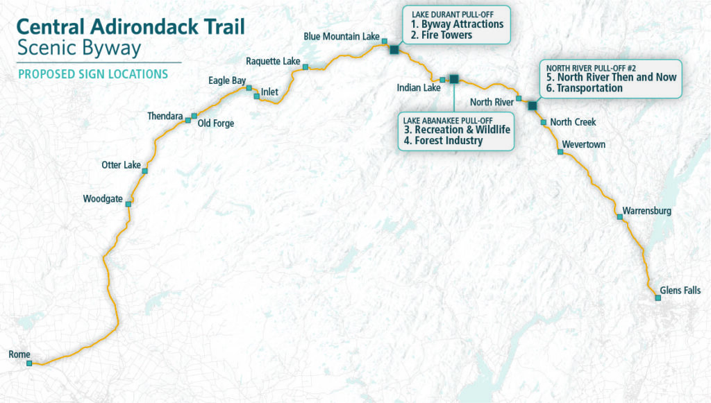
1. Proposed Subjects & Locations of the Six Signs
2. The Signs
Warning: A non-numeric value encountered in /home1/adirond8/public_html/wp-content/plugins/photoswipe-masonry/photoswipe-masonry.php on line 359
Warning: A non-numeric value encountered in /home1/adirond8/public_html/wp-content/plugins/photoswipe-masonry/photoswipe-masonry.php on line 359
Warning: A non-numeric value encountered in /home1/adirond8/public_html/wp-content/plugins/photoswipe-masonry/photoswipe-masonry.php on line 359
Warning: A non-numeric value encountered in /home1/adirond8/public_html/wp-content/plugins/photoswipe-masonry/photoswipe-masonry.php on line 359
Warning: A non-numeric value encountered in /home1/adirond8/public_html/wp-content/plugins/photoswipe-masonry/photoswipe-masonry.php on line 359
Warning: A non-numeric value encountered in /home1/adirond8/public_html/wp-content/plugins/photoswipe-masonry/photoswipe-masonry.php on line 359
3. Online survey to gather community feedback
4. Project Overview
The Central Adirondack Scenic Byway, also known as the Route 28 corridor, spans for 150 miles through the northwest Adirondack Park in New York State from Glens Falls to Rome. The byway follows historic waterways and passes many of the Adirondack’s significant attractions and cultural sites.
Placed along the byway at strategic pull-off points are a series of interpretive signs. These signs provide information about the region’s history, environment, and culture to visitors and local travelers.
Many of these signs were placed years ago and are now showing signs of age. While some are still standing, others are cracked, peeling, or otherwise extremely weathered and cannot be read anymore.
Adirondack Research, LLC was hired to design six interpretive signs to be placed along the Central Adirondack Scenic Byway. These scenes were designed based on input from various sources including the general public, the Adirondack North Country Association, and professionals in the Adirondacks.
Three of the six signs Adirondack Research, LLC was hired to create have now been drafted and are ready for further public review and input.
5. Feedback Questions and Answers
Please check back regularly for updates here.
ANCA Byways Signage Project
Public Input and Response
Overview
Our Google form includes the following questions to prompt responses for public input. These questions are posted after images of each of the designed signs.
General Layout
- Do you think the general layout of the signs are easy to read and aesthetically pleasing?
Information Included
- Is the information included in the signs interesting and relevant?
Illustrations
- Do you think the illustrations match the sign themes and display sign content well? Should any of them be changed or edited?
Maps
- Do any of the maps need more clarification to make them easier to understand?
Other
- Any other questions, comments, or concerns in general?
Questions and answers will be broken down into the following categories:
Questions and Answers
General Layout
No questions yet.
Information Included
Q: Can you make the “Then and Now” sign about Indian Lake’s past and present?
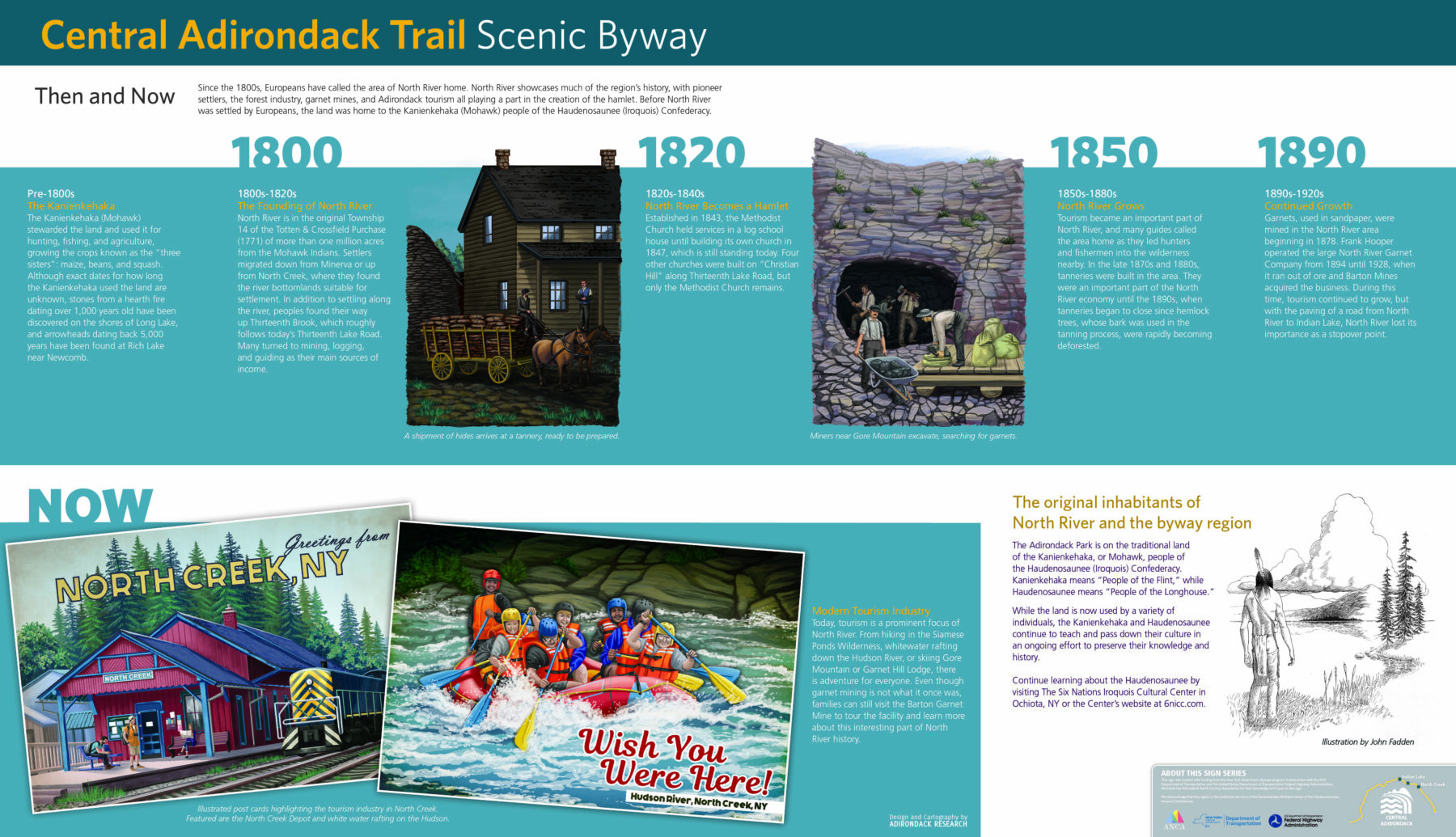
A: According to section 15 of the Central Adirondack Trail Corridor Management Plan, we are tasked to emphasize and enhance visitor experience along the entire Byway. The “Then and Now” sign has been designed to emphasize the North River section of the Byway, which is a specific place along the byway, but we chose to highlight this area because of its past significant impact on many towns along the Byway.
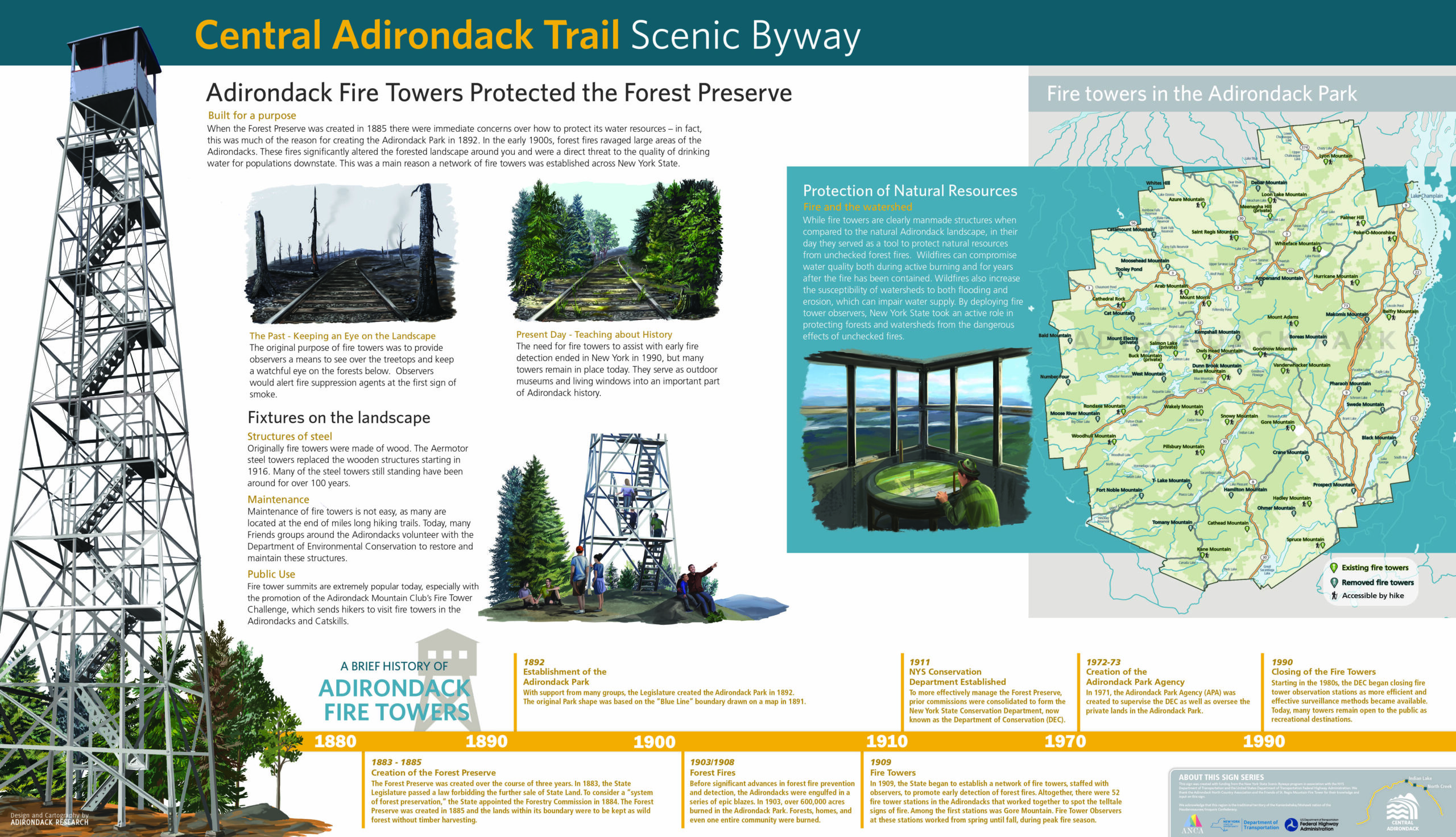
Q: Can the “Fire Tower” sign be placed at Lake Durant, and can you include text highlighting fire towers within 15 minutes of that sign?
A: Yes, the “Fire Tower” sign is currently proposed to be placed at the Lake Durant pull-off area. The fire tower featured is of the Wakely Tower, and we are going to see if we can fit in more information about other nearby fire towers.
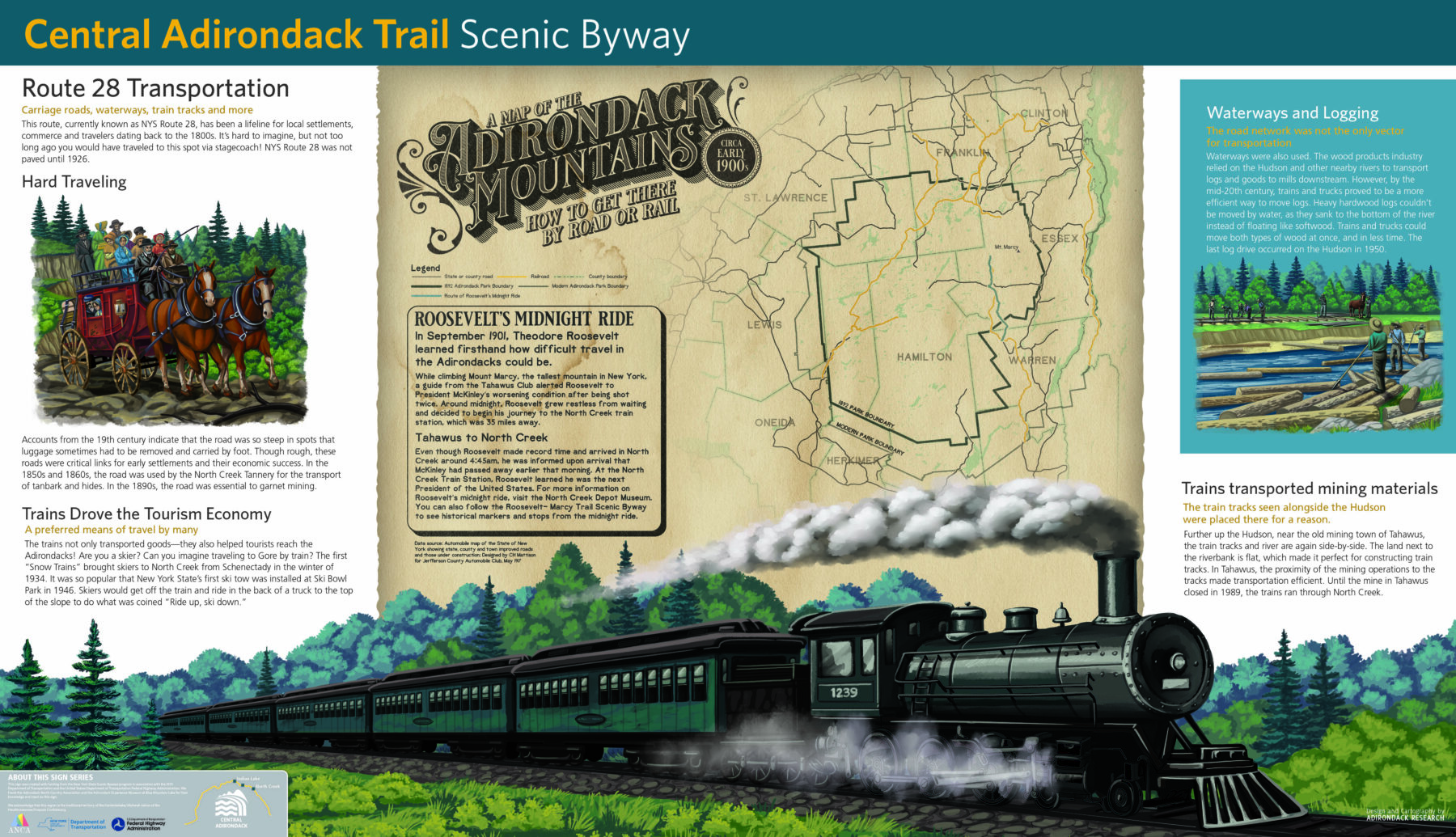
Q: Can the “Transportation” sign have less emphasis on North Creek and add some transportation information related to Indian Lake?
A: Creating the “Transportation” sign was difficult as much of the major transport (railways) focused around North Creek. We tried to highlight how there were many transportation methods in the entire Adirondacks and how they had impacts beyond the towns where hubs may have been located.
Q: In regards to the fire tower sign: Concern about protection of resources started well before the creation of the Park in 1892. The creation of the Forest Preserve in 1885 was a more important milestone. The great fires in no way “completely erase[d] the forests.” There were terrible fires and devastation in certain places, but the forest mostly remained. The concern about the watershed had nothing to do with downstate “drinking water.” Much more significant was the viability of commercial waterways, like the Hudson River and the Erie Canal.
A: Thank you for this information. It is interesting about the viability of commercial waterways related to the impacts from widespread forest wild fires. We will look into that and see if we can adjust or text to better reflect that.
Q: In the “History of North River” sign, you have some errors. Under 1883-1885, the 1885 law did not forbid timber harvest. That did not occur until the state constitution written in 1894, taking effect in 1895. This constitutional provision, which is what makes the Forest Preserve truly unusual, is left out of your timeline. In the 1903-1908 section, it was state regulation of the logging industry that led to fewer fires. It wasn’t just “acres” that burned in these fires. It was hundreds of thousands of acres. Under 1909, can you mention that all the early fire towers were close to roads and quickly became hiking destinations?
A: Thank you for reviewing this information. We will make these changes and we will see if we can fit information about the fire towers being hiking attractions early on.
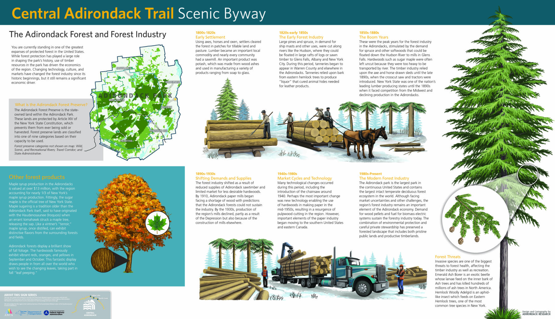
Q: On the “Transportation” sign, regarding the railroad to Tahawus: can you mention that the original mine there was for iron, dating back to 1830s and that the railroad was built during World War II to facilitate a titanium mine on the same site?
A: Our signs are already relatively wordy, and we want to edit down our text. While editing, we will see if we can include different information in a concise way.
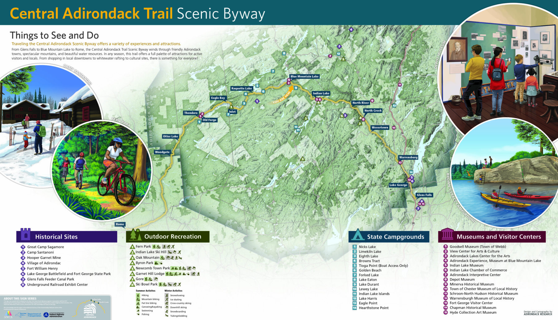
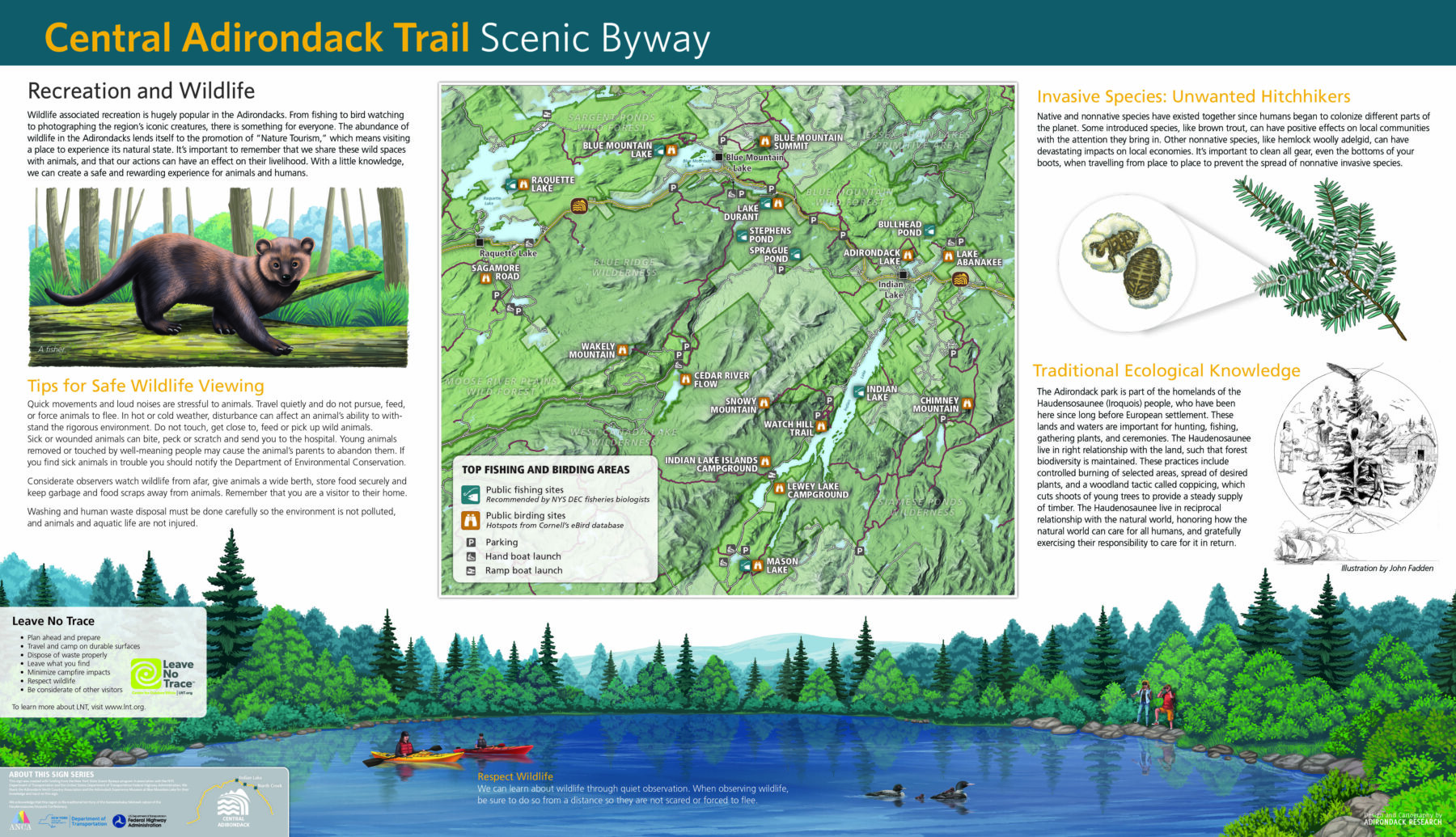
Q: Can you add information for hiking, fishing, boating, and birding?
A: One of the future proposed signs deals with outdoor recreation in the Adirondacks. There will be information on all of these topics available there.
Q: Can you shift the focus from general historical information to more specific information about the local towns?
A: On the “Things to See and Do” sign we include attractions and services at local towns along the byway. We are hoping this will encourage visitors to stop at these towns.
Q: Can the fire tower sign public use paragraph tell families and hikers which fire towers can be climbed? Can you add another color code or the link for the website that has updated information on what can be climbed?
A: This is a good idea. We will consider adding a key that indicates which fire towers can be hiked to or climbed.
Illustrations
Q: Can you check to see what fire tower is illustrated on the sign and make sure it looks like the actual one? Is it Wakely?
A: Yes, the fire tower illustrated is Wakely.
Maps
Q: It is hard to include all of the businesses on the “Things to See and Do” sign. Can you remove specific business names and just have icons for some services, such as diesel, gas, restaurants?
A: This is a good idea. We are considering removing all of the names and just having icons for services.
Other
Q: Can the “Wildlife and Recreation” sign be placed at Lake Durant?
A: The “Wildlife and Recreation” sign is currently proposed to be placed at Lake Abenakee. It pairs very well with the “Forest Industries” sign to show the economics and tourism available along the Byway. The current plan is to place the “Fire Towers” and “Things to See and Do” signs at the Lake Durant pull-off.
Q: The sentence beginning, “From Glens Falls to Blue Mountain Lake …” on the “Things to See and Do” sign contains an example of faulty parallelism (three items in a series: two with prepositions, one without). Can you reword this?
A: Yes, we will re-word this sentence to make it grammatically correct.
Q: Can the “Things to See and Do” sign should be repeated at every stop so regardless of where you join the route you can get the overview and information about attractions?
A: This is a good idea. The sign itself is not planned to be repeated, but information on byways attractions or an overview would be useful to have at each stop. We will talk this over and see what we can do.
Q: The signs are good, but they have way too much text and information for a user to absorb. Can you pair this down?
A: We balance wordiness with graphics to make the storyline as concise as possible. There are examples of signs with more or less text than we present, and we tried to strike a balance across all six signs to make some with less words and some with more.
Q: Can you add QR codes and website links?
A: We have been hesitant to add QR codes or website links for fear they will age quickly and not be useable in the future. These panels are being designed to be placed for about 20 years.
Q: Can you add arts centers to “Things to See and Do”?
A: This is a good idea. We will do this.
Q: What will the signs be made of? What are the installation logistics?
A: The signs will be printed on a hard material called High Pressure Laminate and we will be producing a Request for Proposals to solicit an installer.